18S.20.030 Natural Shoreline Environment Designation (SED).
The intent of the Natural SED is to ensure long-term preservation of shorelines that are ecologically intact or minimally degraded, sensitive to human influence, or retain value because of their natural, unaltered condition.
A. Designation Criteria. The following criteria apply to Natural shoreland areas.
1. The shoreline is ecologically intact and, therefore, currently performing an important, irreplaceable function or ecosystem-wide process that would be damaged by human activity.
2. One of the following applies:
a. The shoreline is considered to represent ecosystems and geologic types that are of particular scientific and educational interest; or
b. The shoreline is unable to support new development or uses without significant adverse impacts to ecological functions or risk to human safety.
3. Such shoreline areas include largely undisturbed portions of shoreline areas such as wetlands, estuaries, unstable bluffs, coastal dunes, spits, and ecologically intact shoreline habitats.
4. Ecologically intact shorelines, as used herein, means those shoreline areas that retain the majority of their natural shoreline functions, as evidenced by the shoreline configuration and the presence of native vegetation. Generally, but not necessarily, ecologically intact shorelines are free of structural shoreline modifications, structures, and intensive human uses. In forested areas, they generally include native vegetation with diverse plant communities, multiple canopy layers, and the presence of large woody debris available for recruitment to adjacent water bodies. Recognizing that there is a continuum of ecological conditions ranging from near natural conditions to totally degraded and contaminated sites, this term is intended to delineate those shoreline areas that provide valuable functions for the larger aquatic and terrestrial environments which could be lost or significantly reduced by human development.
5. The term "ecologically intact shorelines" applies to all shoreline areas meeting the above criteria ranging from larger reaches that may include multiple properties to small areas of a single property and may be inside or outside urban growth areas.
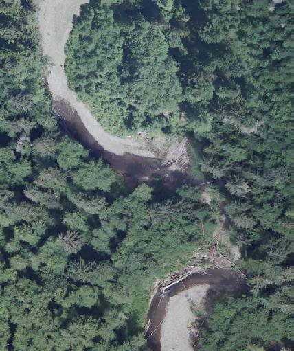
FIGURE 18S.20-1 –
Example of Natural Shoreline Environment
B. Management Policies.
1. Any use that would degrade ecological functions, natural features, and overall character of the shoreline area shall not be allowed.
2. Single-family residential development may be allowed if the density and intensity of the use is limited to protect ecological functions and is consistent with the intent of the natural shoreline environment.
3. New land divisions shall be developed consistent with low impact development (LID) techniques.
4. Private and public enjoyment should be facilitated through low-intensity development such as passive, recreational, scientific, historical, cultural, and educational uses; provided, that no net loss in ecological function and processes will result.
5. Low-intensity aquaculture, agricultural and forestry uses may be allowed when they are limited to ensure no net loss of ecological functions.
6. Commercial, industrial, multi-family residential, and non water-oriented recreation uses should not be permitted.
7. New roads, utility corridors, and parking areas should not be permitted, except as necessary to support uses otherwise allowed by this Title.
8. New development or vegetation removal that would reduce ecological functions or processes should not be permitted.
9. Scientific, historical, cultural, educational research uses, and low-intensity water-oriented recreational access uses may be allowed; provided, that no significant ecological impact on the area will result.
C. Maps. Natural Shoreline Environment Designation maps are found in Chapter 18S.70 PCC – Appendix F.