18S.10.030 Applicability.
A. This Title applies to all shoreline use and development occurring in unincorporated Pierce County. For purposes of this Title, "shorelines" consist of:
1. All marine waters;
2. All rivers and streams downstream from a point where the mean annual flow is 20 cubic feet per second; and
3. All lakes 20 acres in size or larger.
4. For the shorelines listed in subsections A.1 through A.3 of this Section, this Title shall apply to the following:
a. The waters themselves;
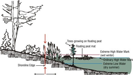
b. Those shorelands extending landward for 200 feet in all directions as measured on a horizontal plane from the ordinary high water mark (OHWM) of the water body;
c. Associated wetlands; and
d. River deltas.
5. Floodways and contiguous floodplain areas landward 200 feet from such floodways.
6. For the shorelines listed in subsections A.1. through A.5 of this Section, this Title shall also apply to the following:
a. The air above the shoreline area; and
b. The land below the shoreline area.
7. Shorelines do not include land necessary for critical area buffers when the buffer is located outside areas identified in subsections A.4 through A.5 of this Section.
8. The shoreline jurisdiction does not include land owned by tribal members or tribes within their tribal reservation, or lands held in trust by the federal government for tribes or tribal members.
FIGURE 18S.10-1 – Ordinary High Water Mark